May 24-25 2008 - Big South Fork National Park Blue Heron Loop - 6.4 Miles
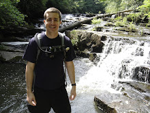
This weekend I hiked Big South Fork National Park for the first time. I was accompanied by my wife and two other individuals. I settled on the Blue Heron loop because it wasn't too long, it was a loop, and a substantial part of the time the trail followed the river.
Things to know. BSF only has a handful of established campsites. These are primarily geared towards drive up campers. If you're a backpacker, you should ignore these sites. Camping along trails is referred to as backcountry camping and requires a $5 permit for the group. Permits can be obtained at the Bandy Creek Visitors station. You can basically setup camp wherever you like as long as it isn't to close to trails, historical sites, or under rock overhangs. Consult the National Park Service website for details. Fires are also permitted.
Note: Originally I used Google Maps to plan our drive from Nashville to Bandy Creek. However, one of our guests pointed out that the location cited by Google Maps was not accurate. They place the visitor's center in Onieda which is too far east. Confirm the location with the map provided by the National Park Service. From the visitor's station it is another 35 miles to the Blue Heron trail head. The parking area at the trail head is quite substantial. There is a great deal of parking there, a train station for a scenic railway, a concession stand, restrooms, a river launch, and historical mockups of the mining town that once existed here. The coal tipple and a train tressel are all that exist in full as the rest of the "buildings" are just metal frames to indicate where things were located and what their function was.
We elected to go counter clockwise from the parking area, something I'd do differently if I had it to do over again. I prefer hiking more the first day than I do the second and I wanted to camp along the river. There simply isn't enough river along this trail if you go counter clockwise... something I glossed over during the planning. If you hike clockwise from the parking lot you will pass through four miles of woods and overlooks before meeting the river. Camp there next to Laurel Branch and you will only have two miles on the way out. Stop along the rapids known as Devil's Jump and you can have fun climbing the boulders and exploring along the river.
There are three campsites that I identified along the river portion of the trail. Using Universal Transverse Mercator (UTM - the metric equivalent of Longitude and Latitude) and the datum WGS 84, I got the following coordinates for the three campsites:
Devil's Jump Campsite = 16 S 719829 4061194
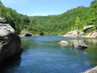
Riverside Camp = 16 S 720763 4060637 (the photo at the top of this posting was taken near here)
Laurel Branch Camp = 16 S 720742 4060444
Of course, these camp names are just ones that I made up, you won't find them on any map put out by the park. These are just places that see habitual use by backpackers. Be advised that the second site in this list is actually too close to the trail for camping (less than 25 feet). However, I've left it on the list as a nice place to sit and rest and to take pictures.
My impressions: I thought this was a very pretty place. Even though it was Memorial Day weekend when we went, we only saw to other groups on the trail the whole weekend. One was a family leaving the river having gone fishing (with some pretty big fish) and the other was some horse riders. We never saw any other backpackers. The trail is a bit too far for us in Nashville. We clocked three hours to the Bandy Creek Visitor's Center and 200 miles flat to the trail head. This was a pretty easy hike for us. Usually we do 5-7 miles a day so this trip became more about putting down the packs and bouldering from time to time. One cool thing worth noting is that you will find a lot of coal just lying around. We used some to keep the fire warm when dry firewood was not terribly abundant. I would highly recommend the park to people in Knoxville. As for us Nashville folk... well, I'm thinking a multi-day canoing trip might be in order.
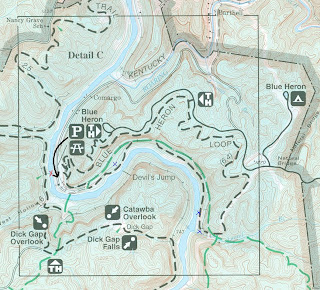
Map Details: While maps are available through the NPS online and off, I recommend purchasing the National Geographic Trails Illustrated Map for BSF. It shows much more detail than the NPS map. You can purchase this map at REI or the visitor's station. I've added some things though. On their map TH means trail head. However, I did not start there. We drove the improved road along the river to the end of the black arrow. That put us near the train station, the tipple, and the train tressel. I have marked the tressel with a red X. It is now a pedestrian bridge. With small blue Xs I have marked the approximate locations (I do mean approximate since I simply eyeballed it based off of my GPS tracks) of the three waypoints I gave earlier marked from West to East in order. We stayed at the third one which is between the trail and Laurel Branch. I recommend it because it is more private than the other two sites that we found and it was big enough for three tents and the fire with plenty of room to spare. Click on this map to enlarge it and better see the Xs.
To download the tracks and waypoints go to
WikiLoc

 January 2008 - North Rim - 16 Miles Total In/Out
 July 21-22, 2007 - Savage Ranger Station to Collins West
 June 21-22, 2008 - Piney River - 9 Miles (Through)
 Fall 2007 - Virgin Falls - 9 Miles (4.5 In/Out)

 April 12-13 - Long Hunter State Park Volunteer Trail - 11 Miles Total In/Out
 May 24-25 2008 - Big South Fork National Park Blue Heron Loop - 6.4 Miles
 Map Details: While maps are available through the NPS online and off, I recommend purchasing the National Geographic Trails Illustrated Map for BSF. It shows much more detail than the NPS map. You can purchase this map at REI or the visitor's station. I've added some things though. On their map TH means trail head. However, I did not start there. We drove the improved road along the river to the end of the black arrow. That put us near the train station, the tipple, and the train tressel. I have marked the tressel with a red X. It is now a pedestrian bridge. With small blue Xs I have marked the approximate locations (I do mean approximate since I simply eyeballed it based off of my GPS tracks) of the three waypoints I gave earlier marked from West to East in order. We stayed at the third one which is between the trail and Laurel Branch. I recommend it because it is more private than the other two sites that we found and it was big enough for three tents and the fire with plenty of room to spare. Click on this map to enlarge it and better see the Xs.