 July 21-22, 2007 - Savage Ranger Station to Collins West
- 11 Miles (Through)
Savage Gulf is a phenomenal park. Having said that, this trail is not the best of what the park has to offer. It's a straight forward through-hike from the Savage Ranger Station on the east side of the park to Collins West on the south side of the park.
Parking at the Savage Ranger Station is great. There are plenty of spots and the lot feels real secure. The Collins West parking is OK. Generally I'm ok with all the lots around Savage Gulf.
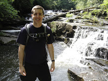
The south side of the trail is pretty rocky and nothing about the trail is really a standout. The South Rim portion of the trail has the park's trademark overlooks. I like the Big Creek Rim and North Rim overlooks better for some reason. We took this trip because it was one of the few trails that we hadn't explored. Plus, the Collins West site is near parking. We staged our gear in one car in Collins West and hiked with just water and some food from the Savage Ranger Station to the vehicles. It was a chance to hike 10+ miles in one day and just enjoy it. That night we retrieved the gear from the car near Collins West and spent the night in Collins West.
There is a stream crossing along the way where you can filter water. I've marked it on WikiLoc below. There is water near Collins West but it's a downhill hike (steep) for a little under a mile. If it has been raining this site would be really cool looking. The creek has cut a swath out of the hill side that looks like an alpine slide.
Waypoints and trail data available at WikiLoc. Do note that the tracks end before the trail does. I had spotty GPS reception on the latter end of the trail.
No comments:
Post a Comment